Costa Rica
In a few words
The republic of Costa Rica got it's name from the genoese mariner Christopher Columbus (1451 – 1506) – who was in service with the Spanish crown – which landed on Isla Uvita in front of Limon October 12th, 1502 and stayed there for almost two weeks. Columbus called the country Costa Rica (rich coast) and Castillo de Oro (golden castle) because he assumed gold resources, that were however never found.
Location and size
Costa Rica covers an area of 51.100 km2 and lies between 8°02' and 11°13' northern latitude as well as 82°33' to 85°58' western longitude. Therefore it is only marginal bigger than Lower Saxony or Switzerland and ranks in terms of size therewith on position 125 on the worldwide ranking list. In the North Costa Rica borders Nicaragua and in the South Panamà. In the West, the country is bordered by the Pacific and in the East by the Atlantic Ocean (the Caribbean Sea). The entire coastline of the country measures 1.200 km, but the one on the pacific side takes 1.000 km into account. At the most narrow site, the distance between the two coasts is only about 120 km long. The longest north-south dimension adds up to 460 km. The highest point in Costa Rica is the Chirripo that measures 3.819 m of altitude, the longest river is Rio Grande de Terraba with it's almost 200 km length, it flows in a widely derived delta (Delta Terraba) with expanded mangrove woods westward of Cortes into the pacific. Lake Arenal with it's 80 km2 is the biggest inland water of the country, but it is artificially damed up.
Population
At present about 4.3 mio residents live in Costa Rica, more than half of them in the Central Valley. In relation to the size of the country, this ends up in about 85 people per km2, that makes it a double compared to 1981 (as a reference: Germany 230 residents per km2). Of all inhabitants are, 87% white, 7% mestizos (descendant of a white and an Indian parent), 3% afro American, 2% Asian and 1% others. Among the Costaricans with afro American roots, there are many descendants of immigrant workers of the West Indies and they therefore speak mostly an English Creole.
The official religion of Costa Rica is Catholicism, but in the country rules the freedom of religion. Among all residents you'll find about 80% Catholics, 15% Protestants and only 5% belong to other religious communities. The capital is San Jose with its 340.000 inhabitants. It lies in the central highlands, in the Meseta Central.
Geology and landscapes
Costa Rica and its neighbors Nicaragua (309 km shared borderline) and Panamà (330 km shared borderline) form a „land brigde“ between the North and the South American continent. The oldest rocks originate from the mesozoic (Jurassic as well as Cretaceous period, 150 mio years) and were found on the peninsula Nicoya. In many parts of the country marine sediments were also found that can be dated into the tertiary or that are even originated in the Paleocene (60 mio years). The continuous compound between the northern and southern American landmasses have been existing only about 3 mio years.
Costa Rica is generally said to be the country of the volcanoes. To some extend 3.000 m high mountain ranges separate the Atlantic and the pacific lowland regions and generate the continental divide. During millions of years the pacific plate positioned itself underneath the Caribbean plate and so lifted the land. The consequences out of it were earthquakes and volcanism, even today, they can be observed at some spots in Costa Rica. Mountain ranges (span. Cordilleras) of volcanic origin are the predominant landscapes. Costa Rica consists of 12 vegetation zones, from mangroves and wetlands to rain forests, cloud forests and dry forests.
Topographically, Costa Rica can be subdivided into five areas: the volcanic mountain ranges of the Cordilleras, the central valley with the capital San José, the wetlands on the Caribbean coast, the central pacific coast and the dry peninsula Nicoya in the northwest. In the „Cordilleras“ you'll find a multitude of extinct as well as still active volcanoes, amongst them the volcano Turrialba. The three most visited volcanoes are: the Poàs, the Arenal and the Irazú.
Geography
The country smoothly passes around from the Caribbean lowlands in the northeast up to the Cordillera de Guanacaste with its four volcanoes that stretch out like a backbone from the border to Nicaragua over southeast to the higher central mountain range. In between this range and the volcanic „Cordillera de Talamanca“ in the southeast lies the Meseta Central or the Central Valley and in it the capital San Josè. The region is compromised in terms of earthquakes as well as eruptions.
Because of its location, Costa Rica is also often called „the garden between two oceans“. Costa Rica is located in Central America and with its 51.100 km2 about as small as Switzerland and forms a natural land bridge between North and South America. Far under the land four plates are brought together (pacific Cocos plate, Caribbean plate, northamerican plate and the southamerican plate), this leads Costa Rica to be a highly active seismic region. The highest mountain is the Chirripo with its 3.819 m above sea level.
Political system
Concerning political stability and social peace, the republic of Costa Rica is a paradigm in Central America with a likewise smooth history as well. Costa Rica partially follows the northern American example in terms of constitutional and institutional matters. The separation of powers is rigorous:
• The president as well as two vice-presidents are elected for four years and by the people of Costa Rica. An immediate presidential re-election is excluded according to the constitution.
• The unicameral parliament ("law-making assembly", asamblea legislativa) consists of 57 delegates which will be elected every four years according to proportional representation without the right to be re-elected.
• The power of dispense justice is independent and self-governing; the allocation of funds takes place via parliament and according to constitutional guidelines.
• The Costarican law follows French and Spanish role models.
• The Costarican supreme court of ballot ("tribunal supremo de elecciones") – as the fourth independent power - watches over the proper execution of all elections.
• Being as well independent and reporting annually the ombudsman called „defensor de los habitantes“ (defender of all residents) is another important contact person for those of the inhabitants who feel being treated unequally or their rights are being violated by the government or an according administration.
Administrative structure of Costa Rica
Costa Rica is being structured in seven provinces:
1. Alajuela (north of the capital)
2. Cartago
3. Guanacaste (northwest)
4. Heredia
5. Limón (east)
6. Puntarenas (southwest)
7. San José (area around the capital)
8. The provinces are split into cantons of which each is divided into different amounts of districts (distritos). Like the provinces, also the cantons and districts are numbered inside their next higher administration unit. There are in total 81 cantons and 470 districts.
9. Governors that are elected by the president rule the provinces.
10. Furthermore Costa Rica is split into six regions (regiones): Central, Chorotega, Pacifico Central, Brunca (also Pacifico Sur), Huetar Atlàntica and Huetar Norte. Those regions are unlike the provinces no administration units, their breakdown was established for socio-economic analysis reasons only. Each region incorporates several cantons of different neighboring provinces. The names of Chortotega, Brunca and Huetar were derived from correspondent indigenous tribes.
Economical environment
Costa Ricas economy is traditionally export-oriented, the best known export goods are or were coffee and bananas, so abroad, even today, they mark the image of the country. Not many people know, that the export of computer chips has become much more important to the country.
Indeed the export of merchandise and services still form the dynamic factor of the Costarican economical development. However, the importance of the traditional agrarian export goods (bananas, coffee, meat and sugar) is continuously declining, they presently represent only 15% of all total exports (in 2000), in the meantime the non-traditional products (like fruit, plants, pharmaceuticals, medical devices, textiles and above all electronic parts) count up to 85% of the export ratio.
The voltage in Costa Rica is normally 110 Volt / 60 Hertz.
Health care / medical treatment
In comparison to other countries in Central America, Costa Rica offers an excellent health care. In urban agglomerations there are many good clinics and hospitals. On the countryside there are much less clinics, but a good and dense network of hospital wards. The red cross is in charge of those hospital wards. The common health care in San Josè is good, but in rural areas there are sometimes lacks, especially in cases of emergencies.
There are about 6.800 doctors in Costa Rica, that means, that on 1.000 residents, we have 1.69 doctor (status 2005). The costs of public health care mount up to about $ 689.654.600 at present time. The average daily nutrition per person counts about 2.610 kcal. The average momentary expectancy of life was 79.3 years in 2009.
Costa Rica heute
The nowadays democratic Costa Rica had for a long time the reputation of being a paradigm within Latin America. Since 1889 the country has had a civil government, since 1949 the still valid constitution. There is a compulsory voting starting at the age of 18. The last civil war lasted 44 days back in 1948, after that the army was disbanded and all security tasks were handed over to the police. For over 100 years there has been a compulsory education, the rate of illiterates shows about 5%. As a calming influence within an unstable region, Costa Rica got strongly involved into the peace making process of the central Americas. In 1987 former President Oscar Arias was awarded with the Nobel Peace Prize.
Some interesting information about Costa Rica:
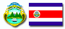 • Since October 21st, 1964, the emblem has been the official national coat of arms of Costa Rica.
• The national anthem is from 1853.
• Political state name: República de Costa Rica (Republic of Costa Rica).
• Form of government: democratic, presidential republic.
• Governance: President Laura Chinchilla.
• Political system: congress of 57 deputies, elected for 4 years.
• Parties:
• Partido Unidad Social Cristiana (PUSC; Christian Democrates).
• Partido Liberación Nacional (PLN, Social Democrats).
• Partido Acción Ciudadana (PAC, left wing liberals).
• Partido Movimiento Libertario (ML, right wing liberals).
• Partido Renovación Costarricense (PRC)
• Unions:
• CTRN (Confederación de Trabajadores Rerum Novarum, socio democrats, close to PLN).
• CMTC (Confederación del Movimiento de Trabajadores Costarricenses, Christian Democrats).
• Furthermore to the Unions, in the private sector there is also the so called “Solidaitista” movement of great importance.
• Judicature: 1 Supreme Court (split into 5 chambers), 4 Courts of Appeal, 7 Province Courts.
• Geography Continent: Centralamerica.
• Geographic location: between 8°11' northern latitude and 83° to 86° western longitude.
• Geographic characteristics:
• Highest mountain: Chirripo (3.819 m).
• Size of the country: 51.032 km2 (world ranking 126), thereof are: 31% Woods, 11% Cropland, 46% Grazing Land.
• Dimensions: NW-SE 450 km, NE-SW 200 km.
• Borderlines: 643 km (with Nicaragua 309 km, with Panamà 330 km).
• Coast: 1.290 km.
• Division: 7 provinces (Guanacaste, Alajuela, Heredia, Puntarenas, Cartago, Limon, San Josè), 81 Cantons, 329 districts.
• Capital: San Josè.
• Population: inhabitants: about 4.195.914 (Source: CIA July 2008).
• Population density: 84.8 people per km2.
• Language: Spanish; second language for a big part of the population is English.
• Ethnic composition: 87% white, 7% mestizo, 3% afro American / mulatto, 2% east Asian (mostly Chinese), 1% indigenous.
• Religious affiliation: 80% catholic, 15% protestant, 5% other.
• Biggest cities: San Josè (324.011), Puerto Limón (57.216), Alajuela (49.568), San Isidro de General (41.912), Desamparados (39.221).
• Mixed time zone: UTC minus 6 hours.
• Birthrate per 1000 people is 19,8 (world average: 25.0).
• Death rate per 1000 people is 4,3 (world average: 9,3).
• Economy: currency is the „Colones“.
• Average income per year per person is $ 2.550.
• Gross domestic product is $ 26,13 mio, so $5.909 per inhabitant (2007).
• Export articles: coffee, pineapple, bananas, textiles, sugar, beef.
• Import articles: raw materials, consumer goods, capital assets, petroleum.
• Industry: food processing, textile and clothing, construction material, fertilizer, synthetic materials, tourism.
• Transportation sector: the railroad network covers 829 km, the road network 28.994 km, the most important.
harbors are Limón, Puntarenas and Golfito, an international airport is in San José.
• Media: radio and television: in each case one public broadcast station but additional to that many private TV and radio programs.
• Press: most important daily newspaper: La Nación, La República, La Prensa Libre.
• Landmarks: Guayabo cult site, volcano Poàs, national park Manuel Antonio and lots of others.
• National anthem: in 1852 the melody was first played in public and the same year taken over as national anthem. The present text was chosen 1903, but confirmed via decree in 1949.
• Translation of the first strophe: noble homeland, your magnificent banner / show us your form of life / under the lucent blue of your sky / rests the peace shimmery white and pure.
Properties Costa Rica
- personal consulting
- indivudial assistence
- object inspection
- verification purchase object
- registers / cadastral studies
- transparent execution
- company foundation
- residencies
- bank accounts / cel phone lines
- project planning
Services
- management
- survey of land
- land and environment studies
- construction assistance
- solar systems
- reforestation
- real estate management
- dealing with authorities
- insurances
- support / advice
Local Team
- Costa Rica expert
- estate agent
- travel agancies / hotels
- lawyers / notary
- accountants / translators
- topographers / engineers
- construction companies / architects
- carpenters / electricians
- solar technicians / and so on...

